10 and 11 May 2014
We arrived at the airport well in time and we are both somewhat apprehensive about what is awaiting us. Our flight - Turkish Airlines TK041 - leaves at 15:40pm.for
Finally Turkish Air TK 794 leaves and we
land at Tel Aviv at 11:20am. Our group leader arranges a taxi which takes us to Beit Shmuel
Guest House in Eliyahu Shama
Street ew City King
David Hotel
 |
| Zion Square |
Our first stop is at Zion Square, Jerusalem ; the liveliest part of
modern Jerusalem Davidka
Square
We finally arrive at the Jewish Market –
the Mahane Yehuda Market, which was built in 1929 to house the Jewish
immigrants. There are lots of lovely delicacies, but we are cautioned that there will
be more time for that later. The photo below shows a stallholder with delicious
Halva, of which we are to buy quite a bit later, even to take home.
 |
| Old British Police Station |
 |
| Halva stallholder at the Jewish Market |
After this brief introduction, we head back
to the guest house to book into our rooms. |
| Overall view of the market |
Later we all leave for the Old City – a
fast walk through the Mamilla Mall allows us to enter the Old City at the
Jaffa Gate and we go to the Christian Quarter. David takes us to the Felafel and
Shwarma King. Their
Shwarma’s are wonderful, but the size of their portions are much too large for us. It is also
quite late at night and as time goes on we learn that is what the Israeli
portions are like. They eat well and I believe it is all healthy food!
Later that evening we have the privilege of watching the Old City
 |
| The Old City at night |
12 May 2014
The second day of our tour starts in earnest; we are up early and after breakfast we set off to the Old City
Big is our disappointment as they are doing
renovations and the Last Supper Room is closed off. We however put it on our
‘to-do list’ for another day. This area has always been regarded by the Jews as
a holy site and they came here to pray in the time when they were denied access
to the Wailing Wall, which is part of the Western Wall of the Temple Mount
 |
| The Last Supper Room (upstairs) |
 |
| Entrance to the site of King David's tomb |
At the Jerusalem Archaeological
Museum
The First Temple was destroyed by the Babylonians in 586 BC, rebuilt 70 years later by Herod to its former splendor and in 68AD the temple was burnt to the ground by the Romans.
This park displays amazing discoveries of Jerusalem during the Second Temple period. From here we walk outside and stand in awe - we are actually seeing the remains of the Old Temple! We notice the Robinson’s Arch – that is the remains of an arch on the south-western side of theOld Temple
The First Temple was destroyed by the Babylonians in 586 BC, rebuilt 70 years later by Herod to its former splendor and in 68AD the temple was burnt to the ground by the Romans.
This park displays amazing discoveries of Jerusalem during the Second Temple period. From here we walk outside and stand in awe - we are actually seeing the remains of the Old Temple! We notice the Robinson’s Arch – that is the remains of an arch on the south-western side of the
 |
| Ruins of the steps at the Temple |
 |
| Remains of the Robinson's Arch can be seen on the wall of the Temple |
Matthew 4:5: Then the devil took him to the holy city and had him stand on the
highest point of the temple. “If you are the Son of God,” he said, “Throw
yourself down. For it is written: “'He will command his angels concerning you,
and they will lift you up in their hands, so that you will not strike your foot
against a stone.'” Jesus answered him, “It is also written: ‘Do not put the Lord
your God to the test.’"
The stone in the photo below is
believed to be the cornerstone of the Temple.
 |
| Cornerstone of the Temple |
We walk past the Jerusalem Gardens
There is so much to see and it is confusing
as we don’t stay long enough in one spot to get oriented. It feels as though we
are in a warren of little streets and corners. We move on to the Jewish Quarter
and get to the Dung Gate. Nehemiah describes it in Chapter 2:13 of the Bible when he suggested
to the Jews to rebuild the wall: By night
I went out through the Valley Gate toward the Jackal Well and the Dung Gate,
examining the walls of Jerusalem, which had been broken down, and its gates,
which had been destroyed by fire. This gate was once only the size of a
doorway but was enlarged in 1948 and has become the main entrance/exit to the
Jewish Quarters (see photo below). The photo immediately below shows the
entrance to the Jerusalem Archaeological Museum ,
with the Old Temple
 |
| The crowd of people are those celebrating the bar mitzvah |
 |
| Dung Gate - see sign on left hand side, against the wall |
Because excavations are not allowed on the Temple Mount Temple Mount David (the Ophel) to the public entrances and the Temple Mount (the Hulda Gates) Temple
 |
| Group photo on top of the stairs in front of the original entrance of the Temple |
 |
| A quiet moment for us all - to think Jesus probably walked these stairs! |
Until 700 years ago the entire length of the Western Wall was accessible but the city's Mamluke and Moslem conquerors built against it. When Jordan occupied Jerusalem in 1948 Jews were denied access to the Wall. In 1967 Jerusalem reunified and the Wall was restored to the Jewish people.
Father William our close friend and priest passed away recently and I promised Brenda that I will say a special prayer for her at the wall. I keep my promise. It is quite a spiritual moment for me as I write two prayers down on a small piece of paper: one for Brenda and one for me and Garry. It is a hustle and a bustle to get to the front of the wall. The men and women sections are separated and each group prays separately. I place my two prayers amongst the bricks in the Western Wall - where there are thousands of prayers visible.
 |
| Men's section at the Wailing Wall |
 |
| Women's section at the Wailing Wall |
Upon leaving the Western Wall we once again
have to go through security (the same as when we arrived) and from there up the
stairs and we come across the life-size Menorah, which has been a symbol of
Judaism since ancient times and which was present in the first and second
temples. This life-size Menorah has been made of gold (see photo below), created by the Temple
Institute is intended for the future Third Temple
 |
| Life-size Menorah |
We walk through the Cardo which shows
remnants of economic activities in the old Roman cities,
with a wall mural that suggests what it might have looked like and we eventually get to the Wohl’s Archaeological Museum, also
known as the Herodian Quarter.
 |
| Remains of the Cardo from Biblical times |
 |
| Mural suggesting what the Cardo looked like at the time |
13 May 2014
I awake on the 3rd day in anticipation as we will be walking to the City of
After a hearty breakfast,
we start our journey…
As we walk along, we look over the
Hinnom and Kidron valleys respectively and I try to
imagine what it was like years ago when it was still undeveloped, as this area
played a vital role in attacks on the city and reference to them are often made in the Bible. Later during our stay we come across a picture of what I believe was the Hinnom Valley in years gone by.
We notice the MontefioreWindmill that is quite a landmark in the distance. In the 19th century the Jews immigrated en masse toJerusalem and the Jewish Quarter of the Old City Jew , Judah
 |
| Picture of the Hinnom Valley in old times |
We notice the MontefioreWindmill that is quite a landmark in the distance. In the 19th century the Jews immigrated en masse to
 |
| Hinnom Valley |
 |
| Garry and I walked to the windmill one free morning |
 |
| Excavations at the City of David |
 |
| The settlement across the way from David’s City |
|
| The ruins of the Royal Quarter at David’s City. Now and excavation site. |
 |
| Sign indicating the City of David |

David
then took up residence in the fortress and called it the City of David
Jotham
rebuilt the Upper Gate of the temple of the Lord and did extensive work on the
wall at the hill of Ophel – 2 Chronicles 27:4.
Afterwards
he [Manasseh] rebuilt the outer wall of the City of David Judah
A sign at the lookout post has the following inscription: “The Kidron Valley is the boundary between the living, in the City of David , and the dead, buried on the Mount of Olives across the way. Archaeologists surveyed approximately 50 burial caves in the village of Silwan that were part of the cemetery of Jerusalem during the First Temple Kidron Valley served generations of aristocratic families in the kingdom of Judah
 |
| Ancient Jewish cemetery and the site still being used |
 |
| Burial caves underneath the homes at the foot of the respective properties. |
 |
| Warren's Shaft. The photos just can't capture the depth of the shaft |
We enter Hezekiah's tunnel and initially walk
thigh-deep in water, but afterwards it drops to ankle-deep and the walk is about 500 meters where we finally exit at the Byzantine pool of Siloam. It is pitch dark inside the tunnel and
we all have headlamps on.
 |
| Walking down into the tunnel in single file, down steep steps |
 |
| Initially the water was thigh-deep but later only the water reached my ankles |
 |
| A life-size model of the Old City |
We climb up to the rooftop and we have
magnificent 360 degree-views of Jerusalem Old City
14 May 2014
This 4th day of our trip is packed with activity! We are all ready and on time, and
when Mohammed (our driver) arrives we pile into his bus. We start off in a north-easterly direction towards
the Judean desert and stop at a look-out point to see the view. It touches me
deeply, as according to the Bible much of Jesus’ time was spent in this area. It was also in this desert where Jesus was tempted by Satan. Matthew 4:8-10: Again, the devil took him to a very high mountain and showed him all the kingdoms of the world and their splendor. "All this I will give you," he said, "if you will bow down and worship me." Jesus said to him, "Away from me, Satan! For it is written: 'Worship the Lord your God, and serve him only.'"
 |
| Magnificent view of the desert |
There are Bedouins
all around in the area and it reminds one of home as the tents they lived in
previously have changed to ‘shacks’ as we know them in South Africa, which
means they are no longer ‘nomads’ in the true sense of the word. From there we
go to the top where the St George’s Monastery is situated. It is beautiful! This monastery is built in the Wadi Qelt Canyon which goes from west to east and along it runs
the main route from Jericho to Jerusalem Jericho
 |
| Road winding down into the gorge where the monastery was built |
The St George’s Jericho
 |
| Garry on what we believe is the old road to Jericho |
 |
| See how deep in the mountains the monastery is located - absolutely magnificent! |
 |
| The caves can bee seen on the right of the photo, where some Bedouins live |
From there we travel north to Qumran , but before we reach it, we pass a Bedouin and his
camel at a sign that says “Sea Level” and we stop. I grab the opportunity to
get onto the camel for ride.


And then we get our first glimpse of the Dead Sea.

Arriving at Qumran
we are greeted by an unexpected site. This is where John the Baptist spent a
great part of his life and it is the place where the Dead Sea Scrolls were
found. The area was already populated 800 BC but was made famous by the Essenes,
a sect at the time, who lived a secluded life at Qumran
towards 200 BC where they studied, wrote the sea scrolls and preserved them. Over
time there were earth quakes, the Essenes were dispersed, Romans lived there, and
the site was eventually disbanded and forgotten. There was interest again after
1947 when Bedouin shepherds found some ancient scrolls in a cave close by.
After that the site has been of interest to archaeologists and many digs took
place here.
 |
| The caves where the scrolls were found can be seen clearly |
The scrolls (their library) were hidden in jars in the caves for nearly two thousand years and included books of the Old Testament, the Apocrypha and the sect’s own works. Some of the scrolls can be viewed at the Shrine of the Book, the Israeli Museum in Jerusalem , which is on our program for later during our visit to Israel
 |
| Storage jars in which scrolls were preserved |
From the excavations by the archaeologists, who then obviously took an interest in the area, one gets a sense of the communal life of the Essenes. There are a number of ritual baths, an assembly hall, central dining room, kitchen, a watch tower, a stable, a pottery workshop and of course their writing room, which is referred to as a Scriptorium. This is obviously where most of the scrolls were written. At present it falls under the Israel Nature and Parks Authority who has developed and preserved the area for tourists.
 |
| Kiln at Qumran with a sign that reads: “This kiln was used to fire the pottery utensils manufactured in the potter’s workshop.” |
 |
| Ritual baths were excavated at Qumran |
The ruins of Qumran are situated on a barren area between the Judean desert and the Dead Sea . While looking at it one wonders what it looked like so many years ago and what made them settle there specifically.
A sign posted at the site reads as follows:
Bedouins discovered this cave in August of
1952. Fourteen thousand fragments of scrolls were unearthed as they sifted
through the dust within. Archaeologists who reached the cave later, uncovered
an additional 1,000 fragments. Scholars believe that a Roman soldier who
entered the cave in 68CE tore the scrolls intentionally and that later raves (sic)
by animals and climate inflicted further damage. As researchers proceeded, the
fragments of these scrolls were pieced together to produce 530 different
scrolls. Publication of these scrolls was completed in 2001. Below is an view of the area, which shows its absolute magnificence.
.jpg) |
| view of the area, with the Dead Sea in the background |
From here we travel further south along the
Dead Sea and finally get to another highlight, namely Masada .
We are once again entertained to a model and then we go up to the mountain by
cable car instead of walking up the Snake Path, which circles its way up the
mountain.
 |
| Taking the cable car up to Masada (instead of walking up the Snake Route) |
Masada is a mountain in Southern Israel,
about 30 miles south of Jerusalem Dead Sea , and all around it
is desert. It is isolated and 14,000 feet above the desert floor. Herod, who was
king of Judea and ruled on behalf of the
Romans, built his fortress on this mountain. It was one of many fortresses
across his kingdom. Herod had a persecution complex and was in fear of his
Jewish subjects, whom he mistreated.
At the time the Romans ruled Judea , but their rule was resented because of their pagan
practices and corruption. Radical resistance started to build up and there were
a number of such groups, which were called ‘zealots’. After the crucifixion of
Jesus these feelings came to a head and in 66 AD the Jews finally rose up, but
they were divided among themselves as many rebel groups existed in Jerusalem Masada and occupied Herod’s fortress. In the 7 years that
they lived there, they extended some of the buildings as additional living
quarters were needed for their approximate 1000 men; they built walls within
walls to safeguard themselves, and built among others, a synagogue.
Eventually the Romans sent in Vespasian
with an army of 70 000 troops and he began to address the revolt. They marched
to Masada , encamped their army there, and
built a wall around the whole mountain as they were determined to root out the
evil of the Sicarii.
The end of the story is that the Sicarii’s
were trapped on the mountain and they eventually went into a suicide pact when
the Romans attacked them, although the suicide version has been disputed by
many historians over time.
One of the extra-ordinary aspects of this
mountain fortress was its water cisterns, some which are still visible today. A
poster displays the following information:
‘“At
each spot used for habitation, both on the summit and about the palace, as also
before the wall, he had cut out in the rock numerous large tanks, as reservoirs
for water, thus procuring a supply as ample as where springs are available.” – Josephus Flavius
The solution of the water problem in the
desert fortress is undoubtedly one of the wonders of Masada .
In order to survive on the mountain, Herod quarried numerous cisterns on the
summit and the northwestern slope. Rainwater that flowed in the floods in the
nearby streams was stored here. The water was collected by a system of dams and
two aqueducts, parts of which can be seen to this day. Two rows of cistern were
dug in the slope, eight in the upper row and four in the lower, that contained
a total of 40,000 cubic meters of water. From the cisterns two paths led up to
the mountain, one from the upper row to the Water Gate in the northwest of the
mountain and the other from the lower row to the Snake Path Gate in the east.
Convoys of animals brought the water up to Masada
along these paths. When they reached the summit, the water was poured into a
system of channels leading into the cisterns throughout the mountain. But a
lover of life like Herod would not be content merely with drinking water. The
water planning of Masada also included
attention to hygiene and recreation. As we can see from the bathhouses and the
swimming pool located in the southern part of the mountain.’
Below are remnants of King Herod’s
splendour.
 |
| One of Herod's rooms with the mosaic floor still reasonably intact |
 |
| Luxury rooms on the northern end of the mountain |
 |
| View over the Dead Sea from the top of Masada |
 |
| The area below Masada where the Romans camped, strategizing their attack |
From Masada we leave for our final treat of
the day – a swim in die Dead Sea . What an
experience! But the word ‘swim’ is actually inaccurate as one cannot swim, one
can only float. The water is salty, yet appears to have an oily layer on top.
Below the water, on the rocks there are crystals and we manage to break some pieces
off, which will obviously be treasured at home as memorabilia.
 |
| I'm floating in the Dead Sea. Absolutely amazing! |
The last quick stop is the Adullam cave
where David hid from Saul. 1 Samuel 22:1: David left Gath and escaped to the cave of Adullam. When his brothers and his father's household heard about it, they went down to him there.
 |
| The area of the Adullam Cave |
 |
| Brinjal with Tahini Sauce. Yummie! |
 |
| We were sitting upstairs on the balcony just under the Solo sign |
 |
| It's still early, but this area (below the restaurant where we ate) will soon fill up and be buzzing |
15 May 2014
Our 5th day turns out to be less hectic. We start out early towards the
Bible Society, but they only open later in the morning and instead we take the
train to our next destination, namely the Yad Vashem Holocaust Museum
The
Holocaust is an interest of both Garry and I, but we are rushed for time and
cannot examine everything that we want to do. We put it on our ‘to do’ list for
another day, but we are not sure if we will get to it as it is quite out of the
way. From there we go to the Children’s Memorial, walk in the gardens and
finally have lunch in the Wold Zionist Organisations – Mt Herzl’ s Memorial
Park.
 |
| A statue in the park outside Yad Vashem, which I believe depicts the horror of the Holocaust. |
 |
| Life size model of Jerusalem during 2nd Temple period |
 |
| Shrine of the Book. The building is in the shape of a jar such as where the scrolls were found |
For dinner Garry and I go to the Bardoni Jerusalem, a lovely Lebanese
Restaurant where we are treated to outstanding food. Falafel to die for, but of
course they take us for a ride with the bill as we don’t order from the menu.
Totally exorbitant, but still it was a huge treat.

 |
| I couldn't believe it. We can hardly finish our meal and they keep on refilling the plates. |
As we get back to the guest house we see disco
lights flashing and hear loud music playing at the Old City Israel
 |
| People milling around at night in the Mamilla Mall |
16 May 2014
Our 6th day proves to be busy once again. We set out and walk past the northern
side of the wall of Jerusalem Roman Plaza Roman Plaza

The piece of ground where the tomb is
situated was discovered in the 19th century and is currently owned
and maintained by the Garden Tomb (Jerusalem )
Association, based in the United
Kingdom Golgotha .
 |
| Place of the skull |
 |
| Water cistern in the garden |
 |
| Overview of the entrance to the Garden Tomb |
 |
| Inside the tomb, believed to be that of Jesus |
From this site we move on to Shachem/Nablus
Road where we view what is believed to be part of the 3rd wall,
built by Jews but overseen by the Romans and we go to a nearby local (Arab)
taxi rank and take a taxi to Bethpage Church. This is believed to be the site
where Jesus rode a donkey into Jerusalem
 |
| Mural at Bethpage Church |
We are
now on the eastern side of the Old City in Jerusalem
We arrive at the Church of the Pater Noster
(Sanctuary of the Eleona), just as they close for lunch. I have the privilege
of snapping a quick picture, but what is remarkable about this church is that
it has plaques of the “Our Father” prayer in 100 different languages. Its
significance is that it is believed to be the site where one of Jesus’
disciples asked him how he should pray. “He
said to them, “when you pray, say: “Father, hallowed be your name, your kingdom
come. Give us each day our daily bread. Forgive us our sins, for we also
forgive everyone who sins against us. And lead us not into temptation”– Luke
11 2-4.
As we look down the valley we are reminded
of prophesies in the Bible:
The Lord comes and Reigns: On that day his feet will stand on the Mount
of Olives, east of Jerusalem, and the Mount of Olives will be split in two from
east to west, forming a great valley, with half of the mountain moving north
and half moving south – Zechariah 14:4.
In my opinion the whole of Zechariah 14
should be read at this point in time.
We spend lunchtime on the Mt of Olives, where one has a splendid view of Jerusalem, but
it is a Friday and the prayers coming from the mosque are reverberating over
the valley, making any quiet time for us virtually impossible. However, the Mount of Olives is mentioned often in the Bible. The Mount itself is home to burial caves from the First and Second Temple periods respectively.
After lunch we start walking down towards
the Old City
When
the church was built here archaeologists discovered artifacts dating back to
the Canaanite period and the 2nd Temple

We continue our downward walk until we
eventually come to the Garden of Gethsemane . Currently
the site belongs to the Franciscans and a sign reads: “Croatians Paul, Anthony
and James, Christians from Sarajevo Knights of the Holy Sepulchre of Jerusalem
in the year of our Lord 1681 purchased the Garden of Gethsemane
 |
| Garden of Gethsemane |
Garry and I have a special time here. We do
some readings and we remember our friends Brenda and the late Father Will in
prayer.
The following signs are displayed there:
“Could
you not watch with me one hour? Watch and pray that you may not enter into
temptation – Matthew 26:40-41”
“With his prayer “Yes Father” and the total
surrender of His will, Jesus triumphed in the darkest night of temptation and
suffering.
He thus showed us that by consenting to the
will of God and committing ourselves to it, we too shall be led out of the
darkness into the light of victory.”
 |
| Basilica of Gethsemane |
 |
| Church at Gethsemane. See how close to the road it is in modern times |
We have a look at Nehemiah’s wall repairs which
took place in 580BC. It is very confusing, especially as sometimes reference is
made to the Temple walls and sometimes to the
City walls (which are not the same), but some of the history of the Temple , Jerusalem
950 BC Solomon built the first temple and
some walls.
586 BC The Babylonians destroyed the temple
and city walls.
516 BC The Jews return and rebuild the
temple.
444 BC Nehemiah rebuilt some of the city
walls through the exiled Israelites who returned from Babylon
141 BC Hasmonian expanded Jerusalem
376 BC Herod restructures the 2nd
Temple
70 AD The Romans destroyed the 2nd
Temple and Jerusalem
135 AD The Romans rebuilt the city of Jerusalem
691 AD Muslims build the Dome of the Rock
where the Temple
1100 was the period of the Crusaders and a
whole lot of changes took place.
1212 Ayyubid built the city walls.
1250 The Muslims and Caliph destroyed the
walls of Jerusalem
1538-1541 Suleman the Magnificent rebuilds
the walls.
The next stop is the Pool of Bethesda at St
Anne’s church. This area marks the birthplace of the Virgin Mary, daughter of
St Anne and Joachim. The church is next to the medicinal baths where Jesus
healed the lame man as described in John 5:1-13.
The remains of the pool of Bethesda can be seen below TEMPLE
 |
| Beautiful garden next to St Anne's Church |
 |
| A snapshot of Garry in the gardens |
 |
| Remains of the pool of Bethesda |

From here we go to the Via Dolorosa, the Stations of the Cross. It begins in the Muslim Quarter and ends at the Holy Sepulchre Church, also known as
It is Friday afternoon and the area is crowded and people are milling around to full capacity. In the midst of this the Franciscan Monks have their procession on Friday afternoons at 4 o’clock and everyone follows them. On the way we pass a number of churches. Of real importance is the Franciscan Convent of the Flagellation and the Condemnation. A quick walk-through shows a beautiful church. On our way to the Church of the Holy Sepulchre we passed the different stations and other sites of importance.
 |
| A site depicting all the Stations of the Cross |
 |
| Procession of Franciscan Monks |
A sign at the Franciscan Convent of the
Flagellation reads: “In this area northwest of the Temple Mount Royal Palace
“A medieval tradition identified the
Fortress Antonia with the Pretorium of Pilate and placed the scourging and
condemnation of Jesus Christ to death on this site.
“This enclosure contains two sanctuaries.
To the right of the entrance is the Church of the Flagellation or Scourging. To
the left is the Church
of Condemnation
The sign further gives information on the Archaeological Museum
Finally we arrive at the Church of the Holy Sepulchre. This site first held a temple built by the Roman emperor Hadrian and was a pagan site. Emperor Constantine later replaced this with a church and the motivation was that it was the place where Jesus was crucified and buried. After the Roman buildings were demolished rock-cut tombs were discovered and one of them was identified as that of Joseph of Armithea. Little of the original structure remained after it was burnt and looted by the Persians in 614, rebuilt only to be hit by an earthquake in 808, and destroyed in 1009 by Caliph al-Hakim. Most of the present building was reconstructed by the Crusaders.
 |
| Inside the Church of Flagellation |
 |
| Tomb to be the other alternative to Jesus' burial site is said to be here underneath the Sepulchre Church |

 |
| Shabbat dinner on Friday Evening at the guest house |
Day 7 arrives. It is Shabbat, which started at sunset on Friday and will continue until sunset tonight. The Sabbath day is Biblical and the Jews follow it strictly. See Leviticus 23:3: There are six days wen you may work, but the seventh day is a Sabbath of rest, a day of sacred assembly. You are not to do any work; wherever you live, it is a Sabbath to the Lord. Shabbat Shalom! That means very few places of interest are open. We get the full impact of this at breakfast. Only the most basic food (probably prepared the previous day). There is no percolated coffee as that is regarded as work. I have to contend with instant coffee from a luke-warm urn.
We all go to the Jerusalem Great Synagogue and it is quite an experience for me. The women and men sit separately (women upstairs and men downstairs). Garry says the men's section was abuzz with talking and men walking around. We found the women section quiet with the women concentrating and following the readings.
As we walk along the streets everything is quiet and it reminds me a bit of South Africa in the old days when Sundays were regarded as holy and very few shops were open. We eventually find a little restaurant open in the suburbs and we have coffee and juice with some of our fellow travelers, after which we all go our own individual ways. Garry and I go back to the Old City and look at sites we wanted to revisit. We also walk by the Western Wall of the Old City and try and work out the dates:
1800 BC City walls were built
950 BC Temple and some city walls built by Solomon
586 BC Temple and city walls destroyed by Babylonians
516 BC Temple rebuilt by returning Jews (from exile)
444 BC City walls rebuilt by Nehemia who returned to Babylon
141 BC City western wall expanded by Hasmonians
37 BC Second Temple restructured and added to it and the retaining walls were addressed
70 AD City of Jerusalem rebuilt by Romans
691 AD Dome of the Rock was built by Muslims where the Temple was before.
1100 The time of the Crusaders
1212 City walls built by Ayyubid) Saladin)
1219 Ayyubid broke down the city walls
1250 City walls destroyed by Caliph (Muslim)
1538-1541 City walls rebuilt by Suleman the Magnificent (Ottoman Turks).
All the shops open after sunset and the city comes to life again.
18 May 2014
This is the 8th day of our trip and we are up early as we are going north. We have to take clothes for 3 days as we are staying at Kerei Deshe Guest House on the shores of the Sea of Galilee. Our current guest house (in Jerusalem) is kind enough to store the rest of our luggage. Mohammed once again fetches us, but asks that we stick to time as he has another appointment in Jerusalem, late afternoon. We drive north, past Ramla, towards Tel Aviv and then along the Mediterranean Coast towards Haifer to Caesarea (it lies on the northern side of Sharon). Fruit trees, vegetable tunnels and other agriculture are evident as we drive along and it proves that a land so barren can in fact provide ample food.
We enter the site at Caesarea's National Park and it stretches from the Roman theatre in the south to the Crusader city in the north. Among others it includes the remains of the Roman Praetorium, its upper palace, the hippodrome and a theater. Herod's amphitheatre, was the first of its kind in Israel and was built between 22-20 BC. Over time it underwent several alterations and it was eventually closed down by the Christian Byzantine rules in 5 AD.
 |
| Back of the theater |
 |
| Remains of the Praetorium |
with the project.
Paul stayed here for two years before he embarked on his journey to Asia. The market place is apparently where he often preached.
From there we travel inland towards Megiddo. Israel Various texts in the Bible refer to Megiddo, with the most important being John's apocalyptic vision of the battle between the forces of good and evil and God's final reign on earth, Revelation 16:16: Then they gathered the kings together to the place that in Hebrew is called Armageddon. This chapter describes God's final judgment on the earth. At this point it is also good to read Zechariah 14, which describes this prophet's vision of the day the Lord is coming.
Other texts that also refer to Megiddo are: Joshua 12:12 and 21, Joshua 17:11-13, Judges 1:27, 5:19, 1 Kings 9:15 refer to Solomon building Megiddo (one of three cities that he built, the other being Hazor and Gezer apart from the Lord's temple, his own palace and the wall of Jerusalem); 2 Kings 9:27; 2 Kings 23:30. Megiddo was one of the Canaanite cities that the tribe of Manasseh was unable to take over, but Joshua defeated some of the Canaanite kings. In 1 Kings 14:25-26 Megiddo is one of the conquests of Pharaoh Shishak.
Tel Megiddo was declared a World Heritage Site. A 'tell' refers to an area which became a hill because many civilizations were built on top of each other over a period of time. Tel Megiddo National Park encompasses the archaeological mound of Megiddo, an area of about 15 acres which rises about 60 meters above its surroundings.
In Biblical times Megiddo's location and its many springs and fertile soil made it an area that was sought after and many battles were fought here.
Many excavations have been done on this site and it comprises among others, a reservoir, the city gate, palaces, stables, temple area, dwellings, a silo and a water system.
 |
| A model of the Tell Megiddo |
 |
| View over the valley from the Tel Megiddo's outlook post |
 |
| Going down into the amazing water system at Megiddo |
We stop briefly at Mount Precipice, also known as Mount of Precipitation or Mount of the Leap of the Lord. It is believed that this is the site which is referred to in Luke 4:29-30 (where the people wanted to throw Jesus down the cliff when they didn't accept him as the Messiah in his hometown). The following sign is displayed there: Rising above the southern part of the Nazareth Mountain Mt of Precipice (397 meters) look out over Nazareth, Mt Tabor and Yizrael valley at its foot. Mount of Precipice is also known as "the leaping mountain" - according to old tradition, Jesus jumped from this mountain when fleeing his pursuers.
On route we drove through Nazareth but from the top of Mt Precipice one can see Nazareth, the city where Jesus grew up. What is amazing, if one reads Acts one will notice that the people of the time walked between Nazareth and Jerusalem - incomprehensible in modern times!
 |
| View from Mt Precipice. See Nazareth in the background |
Many excavations were done here and once again we see a model of the city. We see remains of the buildings, especially of what must have been a spectacular mansion, but I am most impressed by the ancient water system.
 |
| Mosaic floor in remains of the ancient mansion at zippori |
 |
| Tunnel down to the ancient water system at Zippori |
An earthquake divided the mountain and one can see the caves where the Zealots hid in. In the background the Sea of Galilee is visible. Our first glimpse of it!
 |
| Mt Arbel. See the caves where the Zealots hid and in the background our first sighting of the Sea of Galilee |
 |
| Kare Deishe |
 |
| Sea of Galilee from the banks of Kare Deishe |
This is the 9th day of our trip and our second day up north. The weather is warm and humid, but today we start out by walking from the guest house to Kibbutz Ginesar at Genneserat, which is about a 5 km walk. We have noticed green vegetation around us which is remarkable in this arid country and one of the pamphlets I studied gives the credit to the Society for the Preservation of Nature in Israel and other environmental organizations that work hard to ensure that Israel's plants, wildlife, landscapes and historic sites are safeguarded. Of interest is that Israel is one of the few countries in the world where it is an offense to pick wild flowers.
 |
| I walk with David towards Gennesaret. |
 |
| On the Holy Land boat on the Sea of Galilee. What an incredible moment! |
 |
| The way the boat was preserved and transported |
 |
| A model of what the ancient boat would have looked like |
 |
| The actual remains of the boat, preserved as best as possible |
From here we take a taxi towards the site which many believe is that of the Sermon on the Mount - the Mount of Beatitudes - Tabgha. Read Matthew 5,6 and 7. It is to the north of Tabgha and the hilltop overlooks the Sea of Gallilee. There is a monastery built on the site now and it has been declared a Holy Site.
 |
| Site believed by many to be where the Sermon of the Mount took place. The monastery is behind David on the photo. |
"Capharnaum the town of Jesus. He left Nazareth and went to live in Capharnaum by the sea (Gospel of Matthew 4:14). He entered a boat, made a crossing and came into his own town (Gospel of Matthew 9:1).
"The House of Simon Peter. On leaving the synagogue he entered the house of Peter and Andrew with James and John (Gospel of Marc 1:29).
"In Capharnaum the house of the prince of the Apostles was changed into a church. The original walls, however, are still standing (Etheria. late fourth century AD).
"We came to Capharnaum in the house of Saint Peter, which at present is a basilica (Anonium Placentinus. 587).
"The Synagogue. I am the bread of life (Gospel of John 6:43...These things he said while teaching in the synagogue of Capharnaum (Gospel of John 6:59)."
Some other Biblical references to Capernaum: Matthew 11:23, 17:24, 8:5 and 14, Mark 1:21, John 4:46.
An octagonal structure from the 5th century was found after excavations, built around an earlier one-room dwelling which is believed to be the remains of Peter's house. Inside the room graffiti in Aramaic, Greek, Syriac and Latin were found which contained the words, "Lord", "Jesus", "Christ" and "Peter".
 |
| Remains of Peter's house |
 |
| Synagogue at Capernaum where Jesus taught |
Inside the church Garry and I light a candle for Father Will and say a prayer for the Lord to bless his soul.
 |
| The Church of Multiplication on the shores of the Sea of Galilee |
 |
| Inside the church one can see the rock and the mosaic of the loaves and fish in front of it |
 |
| A glimpse of the theatre at Bet She'an |
 |
| Viewing the stage from 'inside' the theatre |
 |
| Ruins of the Gladiator Arena |
We see the ruins of Jericho after a very brief stop and when we pass a Sycamore tree we are reminded of Zacchaeus who climbed into such a tree to get a clearer view of Jesus. Read Luke 19:1-6. A quick stop at the Al-Sultan Spring in Jericho once again gives one an idea of how big a role water and the storing of it played. We stop briefly at the Yardenit Baptismal Site on the Jordan River, just below the southern outlet from the Sea of Galilee. This is however not where the baptism of Jesus took place. That was on the Jordan River, south of Jericho.
 |
| Baptismal site on the Jordan River |
 |
| Water storage of the En Al-Sultan Spring in Jericho City |
 |
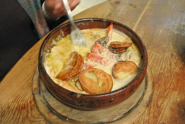
| Lovely fish dish at a restaurant in the Mahane Yehuda Market |
20 May 2014
This is the 10th day of our trip and everyone is exhausted. We have the morning free but there is no time to rest. We go to the Supper room which we couldn't see before.
 |
| Last Supper Room |
 |
| Southern Wall Walk |
 |
| Southern Wall Walk |
 |
| Bags, lampshades etc. all with writing on it and seems to be made from parchment |
 |
| The guide explains the city underneath a city which is the way I understood the tunnels |
We end off the evening by going to an Armenian Restaurant in the Old City. Sydney and Dianne join us. Their food is different with lots of sauce...very rich, but lovely.
 |
| Armenian Restaurant. Beautiful inside with jewelry and paintings and other art |
 |
| A hearty Armenian dish with a rich sauce
|
Our last day as part of the group, day 11 and we are going to Bethlehem and Hebron. We set out early with Mohammed.
 |
| Green vegetation and agriculture as we head towards Bethlehem and Hebron |
The traffic is hectic. Hebron is 40 km south of Jerusalem, a densely populated area on the West Bank. We notice the West Bank Wall and find the city tense with many Israeli and Palestinian soldiers everywhere.
 |
| In Hebron we find a heavy army presence |
 |
| West Bank Wall |
 |
| Walking towards the mosque in Palestinian territory in Hebron to see the Tombs of the Patriarchs |
 |
| Having to put on robes before entering the mosque |
 |
| The tombs inside the mosque |
 |
| The tomb from the Israeli side in Hebron |
 |
| Church of Nativity in Bethlehem |
 |
| Beautiful garden and the view from the restaurant where we ate |
 |
| Te'enim restaurant where we had a super lunch |
 |
| Lovely vegetable curry dish. The owner gave us the onion recipe - delicious! |
 |
| Walking among the houses towards the Scottish church |
 |
| St Andrews Scottish Church with the flag of Scotland flying high |
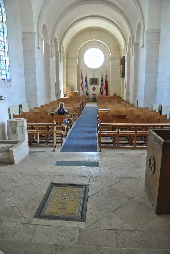 |
| St Andrews Scottish Church |
From here we walk back and come across an Israeli book festival. Oh my word...I have a feast and Garry and I buy quite a number of books. Where we are going to put it all is anyone's guess.
Later that evening, the last evening we go with Sydney and Dianne and have a light meal at the Gent Bistro Bar. We had such a huge meal at lunchtime that Garry and I share a brinjal dish...my favorite!

The next morning we all leave. The rest of the group go to the airport and Garry and I spend one more night in Israel in Tel Aviv. We walk around Old Jaffa, have a lovely meal at a restaurant on the esplanade along the seashore. There is a complete different atmosphere here than in Jerusalem. In the middle of the night we head for the airport and leave to spend a few days in Turkey.